

Prado Dam’s data-driven approach to boosting California’s groundwater supply
Located 2,500 feet (.076 km) downstream of Prado Dam on the Santa Ana River, USGS gaging station 1107400 has been a critical source of flow data for decades. The U.S. Army Corps of Engineers relies on this information to manage flood risk, recharge groundwater supplies and support local ecosystems.
But gathering accurate, reliable flow data during high-water conditions has been a historic challenge at the site. Turbulent conditions and heavy sediment make manual measurements difficult – and sometimes dangerous – driving the need for a safer, more reliable monitoring solution that can perform in extreme weather.
A blueprint for transforming reservoir management
The flow data from gaging station 1107400 has a key role to play in an initiative that Orange County Water District says is poised to “revolutionize water resource management.” The bold, cross-state effort is called the Forecast Informed Reservoir Operations (FIRO) project.
FIRO’s goal? To transform reservoir management at Prado Dam and provide a blueprint for California to increase groundwater recharge. The effort is more important than ever, as California handles severe weather events, water scarcity and the rising cost of imported water.

California’s groundwater recharge opportunity
Groundwater recharge is a process where surface water seeps into the ground through underground aquifers. Intentional recharge, such as controlled releases from dams, is used to store water for later use and to balance and replenish groundwater basins during periods of dry weather.
According to the California Department of Water Resources, groundwater accounts for up to 60% of the state’s total water supply during dry years. During wet years, California’s groundwater basins can collect and hold a massive amount of water – 17 times more than all the state’s above-ground reservoirs combined.
To fully capitalize on groundwater recharge to boost water supply requires ingenuity and a carefully calibrated approach to dam flow management.
Releasing too much stormwater at once from the reservoir can overwhelm groundwater aquifers downstream, resulting in excess flow bypassing recharge basins. The Prado Dam is located only 30 miles from the Pacific Ocean, so excess dam releases will flow out to sea instead of being stored for future use.
A multi-agency effort to adopt data-driven decision making
The U.S. Army Corps of Engineers (USACE), Orange County Water District (OCWD) and the Center for Western Weather and Water Extremes (CW3E) at Scripps Institution of Oceanography at UC San Diego, among others, launched FIRO just over a decade ago.
The groundbreaking program brings data from advanced water monitoring and weather forecasting of storm events like atmospheric rivers together, so that water operators can optimize dam and reservoir management.
By combining data insights and predictive analytics from both water and weather, operators can make better informed decisions to retain or release stormwater temporarily held by dams in reservoirs. The results to date have been game changing.
Turning groundwater recharge into major water supply gains
FIRO’s goal at Prado Dam is to retain more water in the upstream reservoir during the flood season, allowing for a more consistent release during the dry season to maximize groundwater recharge downstream.
Water managers expect to significantly increase water supply for the region by amounts worth millions of dollars – in a wet year, the enhanced monitoring and forecasting tools could boost groundwater recharge by 23,000 acre.
The initial FIRO pilot study was conducted at Lake Mendocino on the Russian River, two hours north of the Bay area. Implementation of the program there was shown to increase the area’s water supply by almost 20 percent.
Reliable flow data holds the key
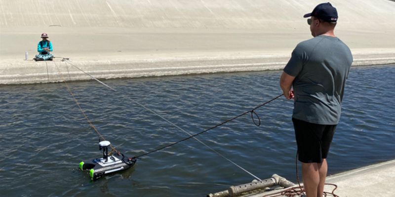
A key factor in FIRO’s success is the integrity of the flow data being used by water managers. To optimize reservoir and dam management, the data must be reliable, accurate and consistent. No easy task. Which brings us back to gaging station 1107400. In the past, the USGS installed an Acoustic Doppler Velocity Meter (ADVM) with an index velocity (IV) rating at the site. But the water turbulence and sediment proved too extreme for traditional solutions, resulting in unreliable flow data during high water events.
In August 2022, as part of work funded by FIRO, CW3E partnered with Xylem to implement a cutting-edge non-contact, AI-powered system at the gaging site, the SonTek-QC4.
Transforming flow measurement with optical sensing technology
The QC4 system uses stereoscopic video cameras with multiple lenses and image sensors to capture scenes from different perspectives, like a pair of human eyes. The system uses the scenes to create 3D imagery and videos, then analyzes the footage with the industry-standard Farneback optical flow algorithm to determine the water’s speed.

Once the water speed is known, the system develops an adaptive learning discharge rating curve to continuously assess and measure flow events. This results in a real-time, accurate measurement of volumetric flow without the need for additional manual streamflow checks.
Because it doesn’t rely on minimum water depth or ground control points, the QC4 delivers reliable data across a wide range of flow conditions – even in challenging environments.
Testing and aligning flow measurement systems
In February 2024, following an extremely wet flood season, the U.S. Army Corps of Engineers logged record high stormwater releases from Prado Dam. During this time, teams from the USGS, CW3E and Xylem made multiple attempts to capture accurate flow measurements using more traditional, manual acoustic Doppler current profilers (ADCPs).
The goal was to compare the traditionally collected data, using the USGC rating system, to the new QC4 system. By comparing the two methods, the results can adapt and strengthen the USGC model.
Comparative analysis confirmed the adaptive learning discharge rating curve developed by the QC4 system aligned closely with the ADCP measurements, the USGS rating, and Prado Dam release data. These findings are a significant step forward as they bring scientists and water operators closer to a consistently reliable and precise measurement system at the gaging site, even in the most extreme flow conditions.
FIRO initiative moves forward, shaping the future of reservoir management
Securing more accurate and reliable data from the Prado Dam gaging station is just one facet of the Prado Dam FIRO project. As the many different pieces come together, a picture emerges of the powerful role that advanced technologies will play in the future of dam and reservoir management. California’s opportunity to dramatically increase groundwater recharge and boost water supply is here.
The FIRO strategy will be tested at Prado Dam over the next several years, with a goal of incorporating it as a permanent feature of dam operations by 2027. FIRO collaborators are even looking at the potential to implement the strategy nationwide, assessing additional sites in California and Washington.
According to Orange County Water District, “The success of the Prado Dam FIRO project showcases the efficacy of innovative water management strategies and sets a precedent for similar innovations across other USACE reservoirs nationwide.”
See how data is powering smarter dam operations. Learn more about the monitoring solutions behind the Prado Dam FIRO project.